
Top Trails near Langs Beach
Click on the map below for more details about each trail.
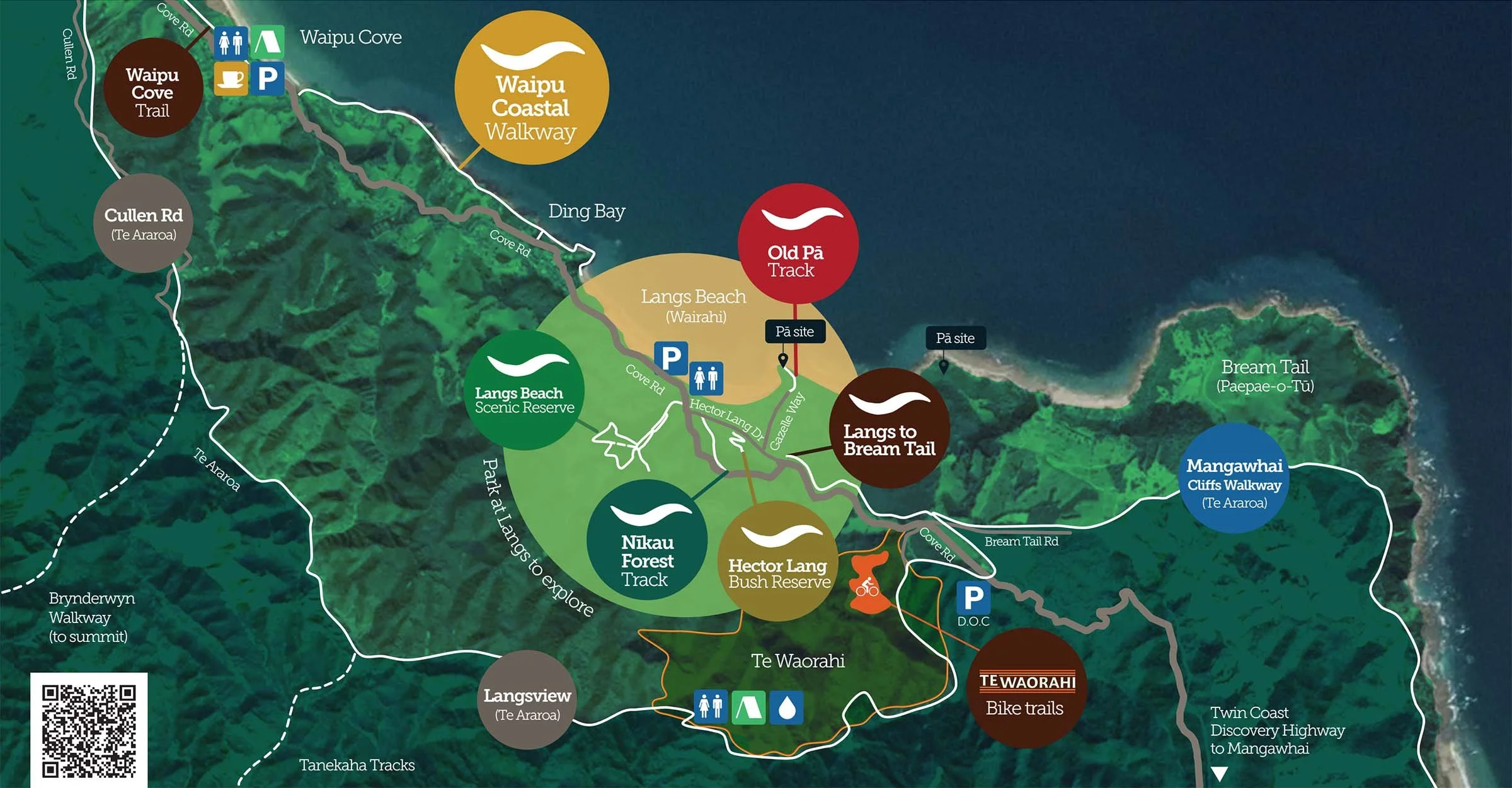
Below you will find information about many of the walking and cycling tracks in the Langs Beach area which are signposted on the map above. Further information and maps will be added over time.
For trails near Langs Beach note that parking and toilet facilities are available on Cove Road, opposite the entrance to the Langs Scenic Reserve. There is also a DOC carpark further south on Cove Road for those visiting Te Waorahi.
For the Waipu trails, parking, food and toilets are available at Waipu and Waipu Cove.
8.5 km : mostly easy
1.5 hr walking
40 min cycling
The Waipu Trail is a gravelled shared path for walkers and cyclists between Waipu and Waipu Cove. Family friendly, it is an easy gradient with one steep hill at Flagstaff. At Riverview, the path has yet to be developed by the Whangarei District Council and you will need to make your way on the road for 500m.
The Walkway offers wide estuary and landscape views. On the seaward side, you will see the Waipu river mouth in the distance, while the Waipu Wildlife Sanctuary is nearby.
The Trail is the culmination of ten years of work by the Waipu Walking and Cycling Trust in collaboration with the Whangarei District Council. Community volunteers have fundraised and led this wonderful amenity.
Directions
Start at either Waipu or Waipu Cove. Easy walk or cycle. One short section is on the road. 8.5km each way. Dogs on lead.

13.8 km : challenging
5-6 hr walking
2 hr cycling
The Cullen Rd cycle and walking loop will take you up Cullen Rd with its spectacular views over Bream Bay. The track will bring you onto the Langsview section of the Te Araroa Trail; crossing the ridge to Te Waorahi and down back to Cove Rd and Bream Tail Rd. The track is undulating with some steep sections and includes some beautiful native bush. It is suitable for advanced cyclists or you can push your bike in some parts over the exposed tree roots.
Directions
From Cove road walk /bike 3 kms up Cullen Rd. At the water tank you will join a metal road and travel past some houses, then further down on your right is a sign to the ridge track. (Langsview) At the end of the Langsview track you come onto the Te Araroa Trail and the shelter, water and toilets area provided there at Waorahi. From here follow the track down to Cove Road and Bream Tail Road south of Langs Beach. Challenging terrain. 6.5km each way . No dogs
5 km : moderate
A spectacular coastal walk with sweeping sea views and rare limestone pancake rocks is a favourite with locals and summer visitors. The track climbs through farmland, native bush and rocky headlands. Keep an eye out for dolphins, orca and seals on the rocks.
The Coastal Track was instigated by the late Alan McKenzie, who together with the Waipu Lions Club, developed the initial route. In 2022, the Wairahi Tracks volunteers agreed to undertake this work for the Whangarei District Council.
After torrential rain in January 2023 caused slips, council contractors and volunteers have spent countless hours restoring the track, building steps, carrying metal and replanting the area.
Directions
Start at Waipu Cove end by wading through the shallow stream at low tide, or from Langs Beach, (entrance from Cove Road opposite Waterman Drive). Moderate difficulty with narrow sections and steps. Can be slippery after rain. 3km each way. Dogs on lead.

2.5 km : easy loop
30 min walking
This was the first project of Wairahi Tracks Trust some five years ago. An agreement was reached with DOC for weed and pest control of the fifteen acre reserve, and access tracks were developed by Wairahi Tracks’ volunteers. The shady walk is a popular and relaxing stroll on hot sunny days or a more energetic morning jog. A number of well signposted tracks wind through the reserve including the recently formed wetland near the road. Here you will see a myriad of wetland planting, including flaxes and native dwarf fuchsia. Thanks to Rural Design for their help and advice on this project.
Directions
Enter the reserve by crossing Cove Road from the carpark and toilet.
Easy 2.5km loop but some uneven sections. No dogs

1 km : moderate
20 min each way
A wonderful stand of our native Nikau and some old tōtara give a presence to this little neck of our woods. The Nikau Forest Trail starts at the Hector Lang Bridge and follows the Wairahi stream to the bridge on Cove Rd at the entry to Langs Beach Estate. Most of the path is flat and easy but there is a narrow uphill section in one particular place. It can be muddy and reasonable care should be taken. You will come upon a small plank bridge that crosses the stream - designed to allow for flood tides and heavy rain. It is holding up very well. Many hours of volunteer labour have gone into weed control and planting of the reserve area. Friday ‘Trackies’ clear away fallen trees and debris after a storm to keep the track open.
Directions
Turn right immediately after crossing the Hector Lang Bridge (at the entry to Hector Lang Drive and Langs Cove subdivision). Follow your nose through the mown riverbank reserve to the walkway. 1km loop. Dogs on lead.

500 m : easy
15 min walking
From the mown reserve at the end of Gazelle Way you will come onto a grassy platform above the Pā. As you walk down you will see what is a defensive Pā. A large trench for repelling the enemy is visible and surrounds the promontory.
Wairahi Tracks volunteers have cleared gorse from the site to reveal this defensive work. Research is currently underway to try and find the old Maori names for this Pā and the headland Pā further along the coast. Over two hundred years of oral history of this area has been lost but old maps may have the clues.
Directions
Access from the end of Gazelle Way at the top of Lang Cove. Easy uphill and downhill walk. 1 km each way. No dogs. There are sharp drop offs so take care.
500 m : easy loop
15 min walking
This little haven was set aside as a reserve as part of the subdivision planning by Hector Lang in the 1990s. You will find lovely native bush that allows you to walk in a peaceful setting.
The Lang family farmed what became Langs Beach from the 1850s when their great, great grandfather William Lang was first granted forty acres in 1856. The Lang family owned and farmed the whole area out to Bream Tail at one point.
The first subdivision of Wairahi Rd took place in 1929, when six sites were sold at auction. (This end of the beach is still often known as ‘Old Langs’). The World wars intervened but by the 1950s Langs Beach was starting to flourish as a coastal holiday destination.
Directions
Hector Lang Reserve has three signposted ROWs from Hector Lang Drive.
Easy walk. 500m. No dogs

1.25 km : easy
30 min walking
12 min cycling
This Shared User Path provides a vital link from Langs to Bream Tail Rd and Te Waorahi, the mountain bike park. An easy, well-formed path for walkers and cyclists, you will cross an interesting wetland area. Classified as a “swamp kauri wetland”, this area is where kauri trees have been buried in peat swamps and preserved for thousands of years. These wetlands are vital, bio diverse habitats to threatened plants and animals, and important in the natural water cycle.
Directions
From Langs Beach, start at Margaret Way at the top of Lang Cove. The path ends close to Bream Tail Rd where you can join the Te Araroa trail by taking Bream Tail Rd to access the Mangawhai Cliffs Trail.
Or cross Cove Rd and enter Te Waorahi mountain bike park via Tarata Place. Park at the DOC reserve carpark further along Cove Rd or beside Bream Tail Rd.
Easy walk or cycle. 30 min each way (walking) Dogs on lead.

8.5 km : challenging
2-3 hour loop walking
A spectacular walk climbing through native bush to remarkable views up and down the coast, and to off-shore islands from rugged clifftops.
Directions
The Langs to Bream Tail path leads to the Mangawhai Cliffs Walkway, ending at the Mangawhai Heads carpark. Keen walkers can complete the full walk from Langs Beach. Moderately steep with many steps. Closed 1 Sep - 31 Oct for lambing. No dogs.

moderate to challenging
allow 1-4 hours
cycling and walking
Te Waorahi is a private conservation project that has generously been made available to the public. The Langsview section of the Te Araroa Trail runs through Te Waorahi and connects to Bream Tail Road. Great emphasis has been given to the creation of a pest free environment with the establishment of regular trapping for possums, stoats, weasels and even wild pigs. New native planting has replaced pine trees and invasive weeds. The impact has been noticeable including regeneration of native bush, an increase in bird song and the return of Kiwi to the area.
Directions
Walk or cycle in from Tarata Place or park at the DOC car park on Cove Rd.
Walking and cycle tracks are well signposted, and a mountain bike park is now in place. You can develop your mountain bike skills with turns and banks set for a thrill.
Moderate to challenging terrain. Allow 1-4 hours. Mountain bikes only. Strictly no dogs.