What’s in our name, Wairahi?
To understand this eternal question we have to look to stories handed down through time to reveal the relatively short history of this amazing place; and to our founding language, te reo, which gives us more essential clues to how any name comes to be attached to any place.

Many of the first waka voyages from across the ocean Te Moana-nui-a-kiwa landed on this east-facing coast. No accident, and they planned to go back.
According to those stories, few landed in one place and stayed right there: these were explorers after all. The ocean was their landscape, islands were simply landing or transition points in that landscape.
It is likely that the voyages that brought them to this place were prompted by their expansive knowledge of this ocean environment. It’s almost too hard in this technological age for us to fully understand their comprehensive skills, except to say that their knowledge traditions, of handing down stories in oral histories coupled with acute observational practices, had enabled accumulation of vast amounts of data including star paths, wind patterns, current and tidal movements, seasonal variations and possibly the most important of all, bird migration routes.
The training for those leader-navigators who chartered the paths of these early waka followed a 20-year learning curve. They knew and could recognise the paths of 100 or so stars by heart, staying up all night to watch their passage across the sky and plot it to points on a navigational compass set out on land with the cardinal points touching the horizon; noting where the stars rose, where they would be at any given time during the night, where they would be in relation to the rising or setting sun. They could detect minor changes in wave patterns that would indicate the swell refraction from land masses they could not see. They had ingenious ways of measuring navigational variables by holding their hand at arms length and using digits and knuckles to calculate anything from 2-90 degrees.
They knew the best time to make these exploratory voyages to lands beyond the horizon and beyond the known island archipelagos at the centre of this ocean plain, was when the tens of millions of birds that shared this ocean habitat made their migratory journeys. For journeys of several days duration the birds had figured they needed calm weather, an assisting wind, and places they could stop off and rest, water or feed before continuing on their journey. The strongest of them would of course fly the route without need for those pauses. But their huge flocks were definitely going somewhere and it made perfect sense to these adventurous explorers to tag along.
They also understood, by the way, that an exploratory voyage carried far fewer risks when the prevailing wind patterns would return before long and carry them back into familiar territory.
To fully understand this relationship with the birds, we have to engage with some extraordinary numbers - teeming millions in fact - of birds moving along these migration paths 1000 years ago. Aotearoa was then, and is now, the seabird capital of the world. There were few natural predators to interrupt their mating rituals. It was a safe haven. They were fearless. Until the europeans arrived with their hardware, boasting of being able to down up to 90 with one shot from a shotgun.

These waka were fast - the fastest craft on water for centuries - nimble, and very seaworthy. The skills deployed in their design and construction are still an inspiration to craftspeople today. Replicas numbering more than 30 now make regular voyages retracing their courses.This then is the context in which the waka Mataatua, Takitimu, Māmaru, Kurahaupo all made landfall along this coast known as Te Tai Tamawahine and continued their exploration. They would have brought their favourite crops including kumara and taro, agricultural know-how and simple technologies involving weaving, stone and shell tools and fishing techniques.

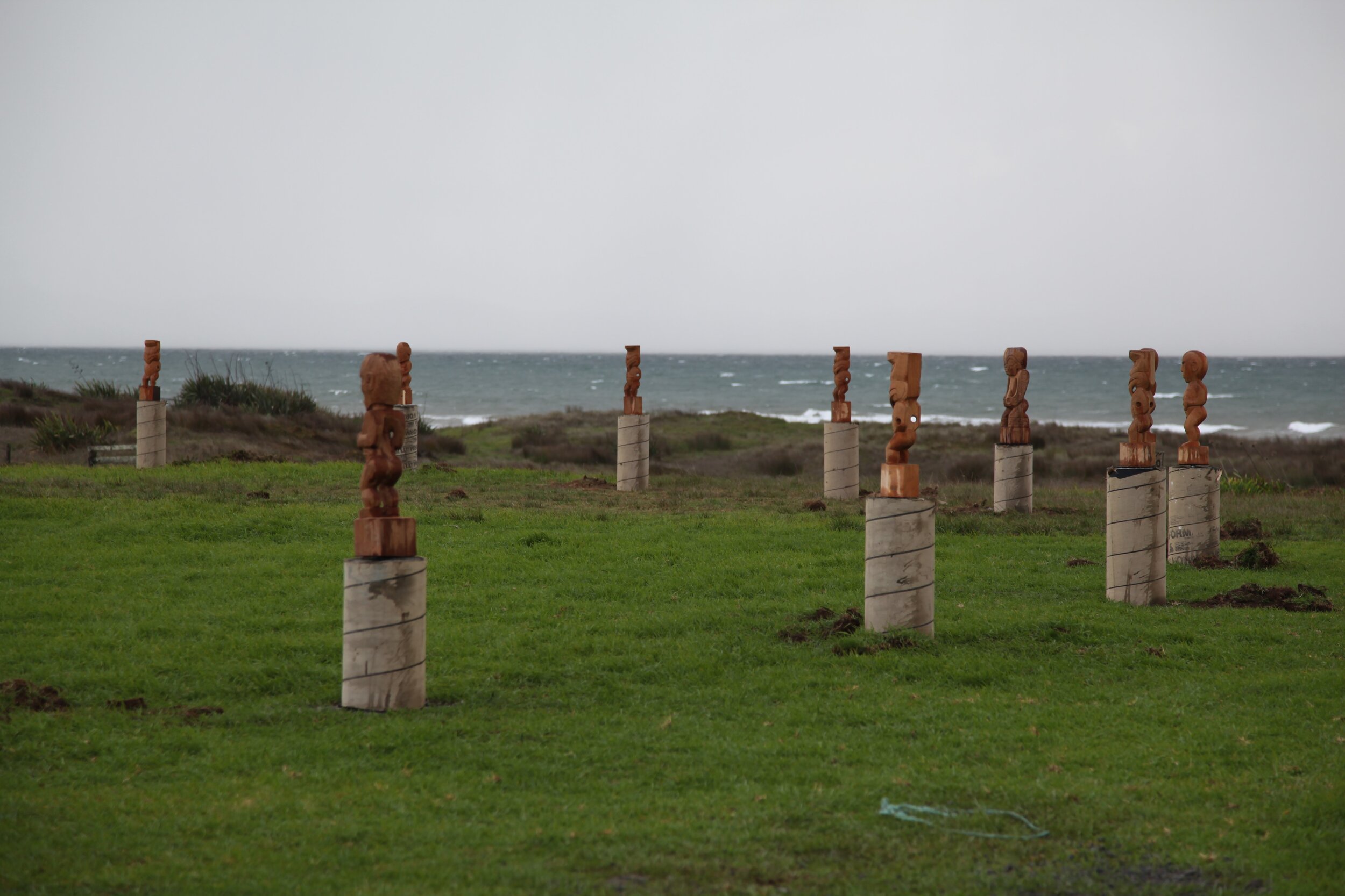
The waka Mataatua under the leadership of Puhi-Moana-Ariki and the Rua-karamea under the captain Manaia both associate more directly with our stretch of water; later renamed Bream Bay by Cook. Some among the 25 or so crew who made the journey on each craft may have been selected to stay and create tiny, family-based settlements. They would have looked for fibre materials similar to those they know from the central Pacific, and built raupowhare like the one pictured here, recreated using traditional techniques in 2002.
We can identify that first contact in time as around 1000 cycles of the reappearance of Matariki in the north-eastern sky ago. Through this period those stories of arrival and settlement have become established in the oral history handed down from generation to generation. The fabric of these connections runs deep and is not explained away by cocky throwaway lines suggesting myths and legends are merely anecdotal. They are real, the whakapapa connecting events and place in time. Tribal occupation may have its own dynamic flow, coming and going in a quiet drift through shifting alliances or ineffective leadership but names gradually foster a sense of identity, building association with memorable events, significant figures and a growing familiarity with the landscape, providing multiple rich sources.
Occupation established under these early liberal norms did not imply ownership in the sense we have now adopted under colonial rule; rather, the nurturing of connection and attachment led to kaitiakitanga: understanding the resources, where are the springs or streams for water, which foliage provides the best materials for shelter, clothing, healing, which berries are edible, where do the crops grow best. These are connections more characteristic of an authentic existence, giving greater meaning to words like ‘dwelling’ as a sense of belonging through a deep connection in time and space.
As time passes one or other of these names outlasts the others, capturing the defining characteristic with a resonance that makes the transition to common use. It’s important to understand that naming in this cultural context is seldom an idle or casual process and has to endure several competing tests of its relevance before settling into wide acceptance. Wairahi translates comfortably as an admirable match to the physical attributes of this place: wai - an expanse of water; rahi - abundant, plentiful, wide. A parallel meaning for rahi - loud, also fits when we relate it to the sound of a crashing eastern swell. Undoubtedly, all these translated meanings suggest a strong sense of a place to love and celebrate. We get to enjoy the inspiration that someone, sometime, formed through his or her authentic existence, landing on this poetic and resonant shorthand to define the connection that will now endures for generations through many more centuries of occupation.
Now, decades after his establishment process, our deep sense of belonging is our cultural landscape and it transcends survey lines and real estate values. Appreciation creates attachment, attachment nurtures identity; 40 generations later the love we all feel in varying ways for this place gives greater meaning to the sentiment expressed in the whakatauki (or proverb):
Ko te whenua ko au
Ko au te whenua
(I am the land, the land is me).
Yes, this name Wairahi is definitively linked to the whakapapa that traces a genealogical line back through those first accounts of arrival and occupation and beyond: to the legends and Māori stories of creation before Rangi and Papa separated to reveal the contours of Papatuanuku’s form. The proposition I am the land is a vivid expression of affection and our inheritance to embrace: we take care of it, it takes care of us. It informs our present-day reality because we are not separate from that wider context. Far from the proposition that it is a ‘location’ on a map in that unemotional and disconnected sense that characterises real estate advertisements, the real responsibility of kaitiakitanga is ours to embrace, nurture, and live to the full.
